
Have Questions? Talk to Expert (Binod)
Rupina La Pass Trek is one of Nepal's most adventurous off-the-beaten-path Himalayan journeys, designed for trekkers who want to leave the busy trails behind and experience the mountains in their most natural form. Situated in the remote Manaslu region of Gorkha, this challenging expedition combines high-altitude wilderness, dramatic mountain scenery, traditional Gurung villages, dense forests, alpine meadows, glaciers, remote valleys, and a spectacular crossing of Rupina La Pass at approximately 4,720 meters.
Unlike popular trekking routes where comfortable teahouses are available almost every night, Rupina La is fundamentally a wilderness camping expedition. Above the villages, our crew carries camping equipment, food, kitchen supplies, and essential logistics into remote areas where accommodation and services are extremely limited. The reward is an extraordinary sense of solitude and a close connection with the Himalayan environment.
The trek begins around Barpak, a historic Gurung and Ghale settlement in Gorkha District. From the village, the route climbs gradually through forests, pasturelands, ridges, and increasingly rugged terrain before reaching the high alpine country around Rupina La. After crossing the pass, the trail descends toward the Budhi Gandaki Valley and can be linked with routes leading into the Manaslu and Tsum Valley regions.
Rupina La is particularly appealing to experienced trekkers because it combines the elements of a genuine expedition without requiring a major technical climbing objective. The route is demanding, remote, and sometimes difficult to navigate, so it should be undertaken with an experienced local guide and a properly organized support team.
At Himalayan Adventure Intl Treks, we organize this journey with careful attention to route planning, camping logistics, acclimatization, food, permits, safety, and local cultural interaction. Our aim is not simply to take you across a mountain pass, but to provide a complete Himalayan wilderness experience.
Nepal has many famous trekking routes, but relatively few provide the same feeling of isolation as Rupina La. The route passes through landscapes where the sounds of modern life gradually disappear. Instead of crowded trails, you encounter forests, grazing grounds, mountain streams, cliffs, glaciers, and traditional villages.
The trail is particularly attractive to trekkers who have already completed popular routes such as Everest Base Camp or the Annapurna Circuit and now want something more remote.
The route also provides a fascinating geographical transition. You begin among cultivated hills and traditional settlements and gradually move into high alpine terrain. Forests become thinner, vegetation becomes sparse, and snow-covered mountains dominate the horizon.
The crossing of Rupina La is the dramatic centerpiece of the expedition. At approximately 4,720 meters, the pass requires a strong physical effort and suitable acclimatization. The descent afterward introduces another side of the Manaslu landscape, with rugged valleys, glaciers, moraines, and remote settlements.
Several existing trekking itineraries place Rupina La around 4,720 meters and describe the route as difficult, with camping required on the more remote sections.
The Himalayas are not only a geographical landscape. They are also a landscape of stories, beliefs, and local traditions.
Local communities around Barpak, Larpak, and the surrounding mountains have passed down stories about the remote highlands for generations. One local tradition connects the name Rupina La with a shepherdess named Rupina who is said to have disappeared while tending sheep in the mountains.
Whether understood as folklore or history, such stories add a special character to the journey. Walking through these landscapes with a local guide gives trekkers an opportunity to learn about the relationship between Himalayan communities and their mountains.
The mountains are not simply destinations for local people. They are sources of water, pasture, spirituality, livelihood, and identity.
This cultural dimension is one reason why traveling with a knowledgeable local guide is so valuable on an expedition such as Rupina La.
The Rupina La Pass Trek travels through the southern and central sections of the Manaslu Himalayan landscape. The route offers changing scenery throughout the journey.
At lower elevations, you encounter:
As the altitude increases, the landscape changes into:
On clear days, the surrounding mountains can include Manaslu (8,163 m), Himal Chuli (7,893 m), Ngadi Chuli or Peak 29 (7,871 m), Buddha Himal, Ganesh Himal, and other peaks of the central Himalayan range.
The exact visibility depends heavily on season, weather, cloud cover, and the position of the trekking route.
The expedition traditionally begins around Barpak, a famous mountain settlement in Gorkha District at approximately 1,900–2,000 meters.
Barpak is predominantly associated with Gurung and Ghale communities and is an important cultural gateway to the remote northern Gorkha mountains.
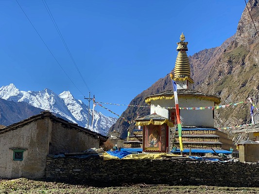
The village itself is worth exploring before entering the wilderness. Stone and traditional houses, terraced hillsides, mountain views, local monasteries, and community life provide an introduction to the culture of the region.
Barpak is also known for its resilience following the devastating 2015 earthquake. The village was heavily affected but has since undergone extensive reconstruction.
For trekkers, Barpak offers something especially valuable: a gradual transition from the accessible middle hills to the remote high mountains.
Some current Rupina La itineraries begin directly with a drive from Kathmandu to Barpak, while others include Gorkha Bazaar or lower villages before reaching Barpak. The exact starting arrangement can be adjusted according to road conditions and the chosen itinerary.
After leaving Barpak, the trail begins to climb toward increasingly remote terrain.
The early part of the journey may pass through agricultural land and forest. Depending on the season, rhododendrons may add color to the hills, while pine, oak, and other Himalayan vegetation create shaded sections of the trail.
Higher up, the forest gradually gives way to open pasture.
These high-altitude grazing grounds are important to local communities because livestock have traditionally been moved to seasonal pastures during warmer months.
The contrast between the cultivated lower hills and open alpine terrain is one of the defining characteristics of the Rupina La trek.
As you approach the pass, the trail becomes increasingly rugged. Walking becomes slower, and the effects of altitude become more noticeable. This is why the itinerary should never be rushed.
The most demanding and memorable section of the trek is the ascent to Rupina La Pass.
At approximately 4,720 meters, the pass represents a significant altitude challenge. The final ascent may involve steep slopes, loose rocks, snow, ice, or difficult trail conditions depending on the season.
The exact conditions can change dramatically from one year to another.
A successful crossing requires:
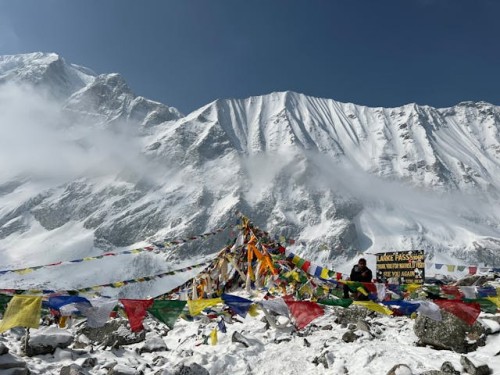
At the summit, the effort is rewarded by a vast Himalayan panorama.
Standing at the pass, trekkers can look across rugged valleys and high mountain landscapes that feel dramatically different from the popular trekking corridors of Nepal.
The pass itself is not merely a high point on a map. It represents the transition from one Himalayan landscape to another.
After crossing Rupina La, the journey continues through rugged terrain toward the Buddha Himal and surrounding high-altitude landscapes.
This part of the route can include rocky moraines, glacial terrain, streams, steep slopes, and remote camps.
Conditions are highly seasonal. Snow can make the trail considerably more difficult, while rain or melting snow can affect river crossings and trail stability.
For this reason, our trekking team evaluates the trail conditions continuously.
The wilderness sections are one of the reasons why Rupina La should not be treated like a standard teahouse trek. The route requires proper expedition planning and a support crew capable of establishing camps in remote areas.
The route is also associated with fascinating natural and cultural features such as the Jherang Caves, traditionally known for their natural water outlets or spouts emerging from the surrounding rock.
Local stories and traditions add a spiritual dimension to such places. Himalayan caves have historically been associated with meditation, religious practice, natural springs, and sacred landscapes.
Conditions, route accessibility, and the exact ability to visit particular sites may vary according to the itinerary and local trail conditions. Our guides can explain the local significance of the sites encountered during the trek.
One of the greatest attractions of this trek is the opportunity to experience genuine Himalayan camping.
There are sections where conventional teahouse accommodation is simply unavailable. Instead, Himalayan Adventure Intl Treks provides a properly organized camping system.
A typical expedition camp includes:
Our porters and support staff transport the necessary equipment and help establish the camps.
After a demanding day of trekking, the dining tent becomes the social heart of the expedition. Trekkers can enjoy hot meals, tea, coffee, and conversation while the mountains surround the campsite.
At night, the absence of city lights creates spectacular opportunities for stargazing.
This is one of the experiences that separates Rupina La from more developed trekking routes.
Food is particularly important during a remote camping trek because there are fewer opportunities to purchase meals along the route.
Our camping kitchen provides three main meals each day, with hot drinks and snacks as appropriate.
Typical meals may include:
Dal bhat remains one of the best trekking foods in Nepal because it provides a combination of carbohydrates, protein, and energy.
In remote areas, the menu depends on what can safely be transported and stored. Himalayan Adventure Intl Treks plans food supplies according to the length, altitude, group size, and camping requirements of the expedition.
Water is available from natural sources such as springs, streams, and mountain rivers, but untreated natural water should not be consumed directly.
Trekkers should carry a reusable bottle or hydration system and use appropriate purification methods.
Our crew can boil water and assist with safe drinking-water preparation during camping sections.
We recommend carrying:
Adequate hydration is especially important at high altitude.
Rupina La is remote, and medical facilities are limited or absent on the wilderness sections.
Our guides carry a first-aid kit and are trained to respond to common trekking problems. However, a first-aid kit is not a replacement for professional medical evacuation.
Trekkers should therefore have travel insurance that covers:
Before departure, inform Himalayan Adventure Intl Treks about relevant allergies, dietary restrictions, or previous altitude-related problems.
The most important safety principle is simple: do not continue climbing when your body is showing serious symptoms of altitude illness.
The Rupina La Pass Trek is considered a difficult and demanding trekking adventure.
The challenge comes from several factors rather than altitude alone.
The trail is much less developed than the major commercial trekking routes.
You spend multiple nights in tents rather than comfortable teahouses.
The route reaches approximately 4,720 meters.
Several stages require sustained walking for many hours.
Conditions can change rapidly in high mountain environments.
Medical facilities, shops, communication, and accommodation are limited.
For these reasons, we recommend this trek primarily to experienced trekkers or physically fit adventurers who are properly prepared.
Beginners should approach this trek cautiously.
Someone who has never completed a multi-day trek may find the combination of altitude, camping, remote trails, and long walking days extremely demanding.
However, fitness and previous experience are not exactly the same thing. A physically strong beginner with appropriate preparation may be able to undertake the expedition with a suitable itinerary and experienced support team.
We recommend several weeks of preparation before departure.
Training should include:
Experienced trekkers will generally find the physical demands more manageable, but even experienced hikers should never underestimate Rupina La.
Rupina La is generally not recommended for young children because of its altitude, remoteness, difficult terrain, and camping conditions.
Children can be more challenging to monitor in remote high-altitude environments, especially when emergency medical facilities are far away.
Families considering the trek should discuss the route with Himalayan Adventure Intl Treks before booking. The decision should depend on the child's age, previous trekking experience, physical fitness, medical history, and the specific itinerary.
The best seasons are generally:
Spring offers relatively stable trekking conditions, pleasant temperatures at lower elevations, and beautiful blooming rhododendrons.
The higher mountains are often clearly visible during good weather.
Autumn is widely considered one of Nepal's best trekking periods.
After the monsoon, the air is generally clearer, trails become drier, and mountain visibility can be excellent.
Winter can bring significant snowfall and freezing temperatures around the pass. Crossing conditions may become difficult or unsafe.
Experienced mountaineering teams may sometimes operate in winter under suitable conditions, but standard Rupina La itineraries are generally better planned for spring or autumn.
Monsoon brings rain, cloud, wet trails, landslide risks, and difficult road conditions in the lower hills.
Because Rupina La is a remote camping trek, monsoon conditions can create additional logistical challenges.
For the best combination of trail conditions, weather, and mountain visibility, Himalayan Adventure Intl Treks generally recommends spring and autumn.
Temperatures vary considerably according to altitude and weather.
The following figures are approximate planning ranges rather than guaranteed conditions:
| Location | Approx. Altitude | Spring | Summer/Monsoon | Autumn | Winter |
|---|---|---|---|---|---|
| Barpak | 1,915 m | 5°C–20°C | 10°C–25°C | 6°C–21°C | 0°C–15°C |
| Gai Kharka | ~2,900 m | 0°C–15°C | 5°C–18°C | 1°C–16°C | -5°C–10°C |
| Rupina La Base Camp | ~3,700–3,800 m | -5°C–10°C | 0°C–12°C | -4°C–9°C | -10°C–5°C |
| Rupina La | ~4,720 m | -8°C–5°C | -2°C–8°C* | -6°C–4°C | -15°C–-2°C |
| Mu Gompa | ~3,700 m | -2°C–12°C | 2°C–15°C | -1°C–13°C | -8°C–5°C |
| Machha Khola | ~869 m | 15°C–30°C | 20°C–35°C | 16°C–31°C | 10°C–25°C |
*Actual high-pass conditions can be substantially colder, especially with wind chill and snowfall.
The exact itinerary can be adjusted according to trail conditions, group fitness, weather, and permit requirements. A representative Himalayan Adventure Intl Treks itinerary is:
Meet our airport representative and transfer to your hotel.
In the evening, our trekking team conducts a briefing covering the itinerary, equipment, safety, and preparation.
Overnight: Hotel in Kathmandu.
Use this day to check your equipment and prepare for the remote camping expedition.
Your guide will review the trek and answer questions about altitude, food, camping, and safety.
Overnight: Hotel.
Travel toward Gorkha and continue by road to Barpak.
The drive provides views of Nepal's middle hills, rivers, terraced farmland, and rural communities.
Overnight: Lodge/homestay in Barpak.
Begin trekking through forests, pastureland, and mountain terrain.
As you climb, settlements become fewer and the landscape increasingly wild.
Overnight: Camp.
Continue toward the high alpine region.
The vegetation becomes thinner as altitude increases.
Overnight: Camp.
A flexible acclimatization day can be incorporated according to the group and route conditions.
Short hikes around camp help the body adjust to altitude without adding unnecessary stress.
Overnight: Camp.
Trek toward the base camp beneath Rupina La.
The trail becomes more rugged and the surrounding peaks increasingly impressive.
Overnight: Camp.
This is the most challenging day.
Start early and climb toward Rupina La. After reaching the pass, enjoy the Himalayan panorama before beginning the descent toward the next camping area.
Overnight: Camp.
Descend through rugged terrain toward the Buddha Himal landscape.
The scenery changes from high pass terrain to rocky valleys and glacial surroundings.
Overnight: Camp.
Continue descending through remote mountain country.
The trail gradually becomes greener as you lose altitude.
Overnight: Camp.
The route gradually approaches more established sections of the Manaslu trekking network.
Traditional settlements begin appearing again.
Overnight: Camp or local lodge depending on the selected route.
Overnight: Lodge/camp.
Note: Himalayan Adventure Intl Treks can also design longer 14–21 day itineraries combining Rupina La, Tsum Valley, and the Manaslu Circuit.
One of the biggest advantages of the Rupina La route is that it can be incorporated into a longer Manaslu adventure.
After descending from the remote Rupina La section, trekkers can connect with the broader Manaslu trekking corridor.
A longer itinerary may combine:
Rupina La Pass + Tsum Valley + Manaslu Circuit + Larkya La Pass
This creates a much more comprehensive exploration of the Manaslu region.
The combined journey can include:
Several established route variations connect the Rupina La route with the Manaslu Circuit, although the exact connection depends on the chosen itinerary and current trail conditions.
Because parts of the Manaslu and Tsum Valley routes fall within restricted areas, foreign trekkers need the appropriate trekking permits.
The Nepal Department of Immigration states that restricted-area trekking permits are required and that such permits are issued through authorized trekking agencies. Solo trekking is not permitted in these restricted areas.
For a Rupina La itinerary entering the relevant Manaslu restricted area, the current official Manaslu permit rates are:
| Season | Manaslu Restricted Area Permit |
|---|---|
| September–November | USD 100 per person/week |
| December–August | USD 75 per person/week |
| Additional days in peak season | USD 15/day |
| Additional days in other season | USD 10/day |
If the itinerary also enters the restricted Tsum Valley, the current official Tsum Valley rate is:
| Season | Tsum Valley Restricted Permit |
|---|---|
| September–November | USD 40 per person/week |
| December–August | USD 30 per person/week |
| Additional days | USD 7/day |
The Manaslu Conservation Area Permit (MCAP) is also required for routes entering the conservation area. Current Nepal Tourism Board information lists the foreign-national MCAP fee at NPR 3,000 per person.
Permit requirements can vary according to the precise route. Himalayan Adventure Intl Treks will verify the current requirements before your trek and arrange the necessary permits.
The cost depends on the duration, group size, transportation, camping requirements, permits, staff numbers, food, and whether the trek is combined with Tsum Valley or the Manaslu Circuit.
Unlike teahouse treks, Rupina La requires a significant camping operation.
Your package may include:
Himalayan Adventure Intl Treks provides customized quotations based on your group size and exact itinerary.
For the most accurate current price, contact our team with your preferred travel dates and number of trekkers.
Because this is a remote camping expedition, packing correctly is essential.
Himalayan Adventure Intl Treks provides a detailed packing list during the pre-trek briefing.
Altitude is one of the most important considerations on Rupina La.
The route climbs from approximately 1,900 meters to more than 4,700 meters. The body needs time to adjust.
Symptoms of mild altitude sickness can include:
More serious symptoms require immediate attention.
Never ignore worsening symptoms simply because you are close to the destination.
Our guides monitor trekkers throughout the expedition and can modify the itinerary when necessary.
The most important rules are:
Walk slowly.
Drink enough water.
Eat regularly.
Sleep adequately.
Avoid unnecessary alcohol.
Tell your guide immediately if you feel unwell.
Rupina La is very different from Nepal's more commercial high-pass routes.
| Feature | Rupina La | Annapurna Two Passes | Langtang Ganja La |
|---|---|---|---|
| Remoteness | Very high | Moderate | High |
| Maximum altitude | ~4,720 m | Over 5,300 m depending on route | Around 5,000 m+ |
| Accommodation | Mainly camping on remote sections | Mostly teahouses | Teahouse + camping |
| Crowds | Very low | Moderate | Low |
| Cultural focus | Gurung/Ghale and Manaslu communities | Gurung, Thakali, Manang | Tamang and Tibetan-influenced |
| Main attraction | Wilderness and Rupina La | Multiple high passes | Ganja La and Langtang |
| Logistics | Complex | Easier | Moderate |
| Experience required | High | Moderate–high | High |
If your priority is solitude and wilderness, Rupina La is an excellent choice.
Rupina La is not a trek where you simply follow a marked trail from one lodge to another.
It requires careful logistics.
At Himalayan Adventure Intl Treks, we focus on:
Our trekking team understands the Himalayan environment and the importance of local communities.
Our guides help with navigation, pacing, altitude awareness, camping coordination, and cultural interpretation.
Our support staff manage tents, food, cooking equipment, luggage, and camp organization.
Weather and trail conditions can change. We can adapt the itinerary where necessary.
We encourage trekkers to respect local traditions, avoid unnecessary waste, protect natural resources, and support local communities.
Private and small-group expeditions allow us to provide a more personal trekking experience.
The remote character of Rupina La makes environmental responsibility especially important.
There may be no waste-management infrastructure in the wilderness.
Trekkers should:
The goal is to leave the mountains as beautiful as we found them.
It is a difficult trek suitable mainly for experienced trekkers or physically fit adventurers with proper preparation.
The highest point is approximately Rupina La Pass at 4,720 meters.
A standard Rupina La expedition commonly takes around 18–19 days, depending on the route. Longer combinations with Tsum Valley and Manaslu can take more than 20 days.
Yes. Camping is essential on the remote sections because conventional teahouses are not available throughout the route.
Beginners are generally not our first recommendation. Previous trekking experience and strong physical preparation are highly beneficial.
Restricted-area rules prohibit independent solo trekking on applicable restricted routes. An authorized agency and appropriate trekking arrangements are required.
March, April, May, September, October, and November are generally the preferred months.
Winter can be considerably more difficult because of snow and freezing temperatures. It should only be considered after careful route and weather assessment.
Monsoon is generally not preferred because of rain, slippery trails, landslide risks, and difficult road access.
There are basic accommodation options around some villages, but the remote high-altitude sections require camping.
The camping kitchen prepares meals such as dal bhat, rice, vegetables, pasta, noodles, soup, potatoes, eggs, bread, tea, and coffee.
Natural water sources are available, but water must be purified or boiled before drinking.
Connectivity is limited and unreliable in remote sections. Do not depend on mobile coverage for emergency communication.
Yes. We strongly recommend insurance covering high-altitude trekking and emergency evacuation.
Yes. A warm sleeping bag suitable for high-altitude camping is essential.
Yes. This is one of the most rewarding ways to extend the expedition.
Yes. A customized itinerary can combine Rupina La with Tsum Valley and the Manaslu Circuit.
For restricted-area sections, appropriate agency and guide arrangements are required under Nepal's regulations.
It is primarily a trekking and high-pass expedition rather than a technical mountaineering climb. However, snow and ice conditions can make the pass significantly more difficult.
Everest Base Camp is a famous and relatively developed trekking route with many teahouses and trekkers. Rupina La offers much greater solitude, camping, and wilderness.
Generally, yes. The remote camping, high pass, limited infrastructure, and navigation challenges make Rupina La considerably more demanding.
You should be comfortable walking uphill for several hours on consecutive days and carrying a daypack.
Good-quality waterproof trekking boots with strong grip are recommended.
Yes. Himalayan Adventure Intl Treks can arrange porters and camping support staff.
Safety comes first. The guide and company may modify the itinerary, delay the pass crossing, or choose a safer alternative when conditions require it.
Yes. We can design private itineraries based on your available time, experience, group size, and interest in Tsum Valley or Manaslu Circuit.
Depending on weather and route position, views may include Manaslu, Himal Chuli, Ngadi Chuli/Peak 29, Buddha Himal, Ganesh Himal, and other central Himalayan peaks.
Barpak provides an authentic introduction to Gurung and Ghale culture and serves as an important gateway toward the remote mountain trails.
No. Compared with Everest, Annapurna, and other major trekking corridors, the Rupina La route receives far fewer trekkers.
It is not generally recommended for young children. Families with older teenagers and previous trekking experience should discuss the route with our team.
The Rupina La Pass Trek is for travelers who want something more than a standard Himalayan holiday.
It is for those who want to walk through forests where few trekkers pass, camp beneath remote peaks, experience traditional mountain communities, cross a demanding Himalayan pass, and spend nights surrounded by wilderness.
From the culturally rich village of Barpak to the high slopes of Rupina La, every section of this journey offers a different perspective of Nepal.
The route combines adventure, culture, solitude, camping, and spectacular mountain scenery in one unforgettable expedition.
At Himalayan Adventure Intl Treks, we can arrange Rupina La as a private camping expedition or design an extended itinerary combining Rupina La, Tsum Valley, and the Manaslu Circuit.
If you are ready to explore one of Nepal's less-traveled Himalayan routes, contact our trekking specialists to discuss your preferred dates, group size, experience level, and itinerary.
Come beyond the popular trails and discover the remote heart of the Manaslu Himalayas with Himalayan Adventure Intl Treks.
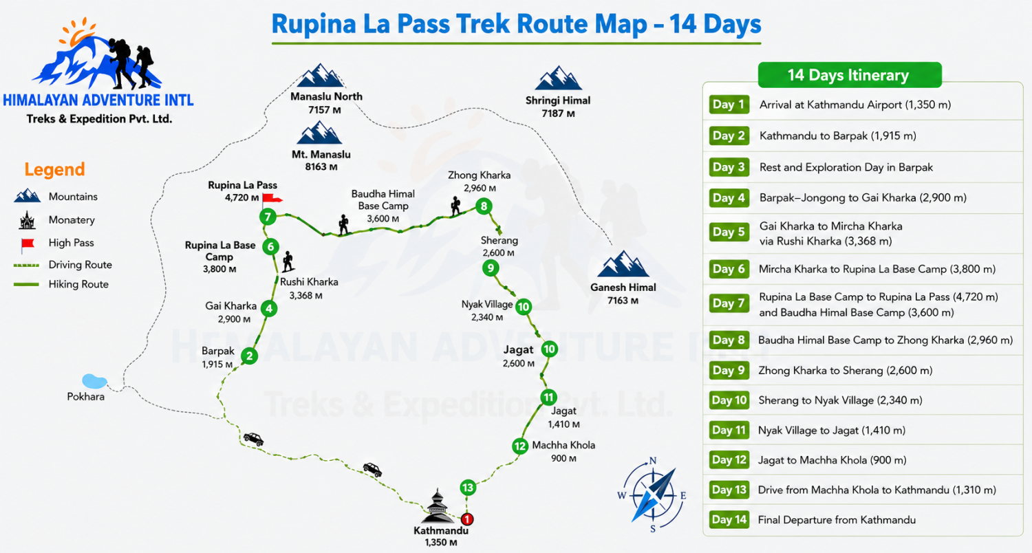
Welcome to Nepal and the beginning of your exciting Rupina La Pass Trek with Himalayan Adventure Intl Treks. Upon your arrival at Tribhuvan International Airport in Kathmandu, one of our representatives will be waiting outside the terminal to welcome you. After completing immigration, collecting your luggage, and meeting our representative, you will be transferred comfortably to your hotel in Kathmandu.
The drive from the airport to your hotel generally takes around 30 minutes, depending on traffic conditions. Kathmandu is the vibrant capital city of Nepal and serves as the main gateway for trekking adventures throughout the Himalayas. During the short drive, you can already experience the lively atmosphere of the Kathmandu Valley, with its busy streets, traditional architecture, temples, shops, and colorful markets.
After checking into the hotel, you will have time to rest and recover from your journey. If you arrive early and feel energetic, you may take a short walk around the nearby neighborhood or explore some local shops. Your trekking team can also brief you about the journey ahead, including the remote nature of the Rupina La route, camping arrangements, trekking equipment, safety considerations, and the expected conditions at higher elevations.
Rupina La Pass Trek is an adventurous and relatively remote Himalayan journey. Unlike some of Nepal's more developed trekking routes, this trail passes through peaceful mountain settlements, forests, alpine landscapes, and isolated valleys where camping is an important part of the experience. Therefore, preparation and a good understanding of the route are essential.
In the evening, you can enjoy a welcome dinner and meet your trekking team. Your guide will check your essential equipment and answer any final questions about the trek. Overnight accommodation will be at a comfortable hotel in Kathmandu.
Accommodation: Hotel
Meals: Not included unless otherwise arranged
Transportation: Approximately 30-minute airport transfer
Maximum Elevation: 1,350 m
Trekking Area: Kathmandu Valley
Today, your Himalayan adventure officially begins as you leave Kathmandu and travel toward the beautiful mountain settlement of Barpak. After an early breakfast, you will meet your trekking team and begin the scenic drive toward the Gorkha region. The journey covers approximately 180 kilometers and normally takes around 6–7 hours, although road and traffic conditions can influence the travel time.
As you leave Kathmandu, the landscape gradually changes from the densely populated Kathmandu Valley to green hills, terraced farmland, rivers, and traditional rural settlements. Much of the route follows winding mountain roads, offering fascinating views of Nepal's countryside. Along the way, you will pass through villages where local people continue traditional farming and mountain lifestyles.
Barpak is situated at approximately 1,915 meters and is one of the significant settlements associated with the beginning of the Rupina La trekking region. The village is surrounded by impressive green hills and Himalayan landscapes and provides a wonderful introduction to rural mountain life. As you approach Barpak, the road becomes increasingly mountainous, and the scenery becomes more peaceful and dramatic.
After arriving in Barpak, you will check into a local lodge and have time to settle in. Depending on your arrival time and energy level, you can take a gentle walk around the village. The evening is an excellent opportunity to interact with local residents and learn about their culture, traditions, architecture, and daily life.
Your guide will also provide a detailed briefing about the trekking days ahead. Because the route becomes increasingly remote after Barpak, this is an important opportunity to make sure your personal belongings and trekking equipment are properly organized.
Enjoy a warm dinner at the lodge and rest well. Tomorrow is planned as an acclimatization and exploration day, allowing your body to adjust to the mountain environment before the challenging sections of the trek.
Accommodation: Lodge
Meals: Breakfast, Lunch, and Dinner
Driving Distance: Approximately 180 km
Driving Duration: 6–7 hours
Elevation: 1,915 m
Destination: Barpak
Today is a valuable rest and acclimatization day in Barpak. Rather than continuing immediately toward higher elevations, you will spend the day relaxing and exploring the village and surrounding areas. Taking a rest day at this stage helps your body adjust gradually to the increasing elevation and prepares you physically and mentally for the more demanding trekking days ahead.
After breakfast, you can explore Barpak with your guide. The village is known for its attractive mountain setting, traditional houses, narrow paths, cultivated hillsides, and strong community atmosphere. Walking through the settlement provides an opportunity to observe the everyday lifestyle of local mountain communities.
During your exploration, you may see residents working in their fields, caring for livestock, preparing traditional foods, or carrying out daily household activities. The surrounding hills are covered with forests and agricultural terraces, creating a peaceful environment far away from the busy streets of Kathmandu.
Your guide can introduce you to local customs and explain aspects of the area's history and culture. You can also photograph the beautiful surroundings and enjoy views of the green hills and distant Himalayan peaks when weather conditions are clear.
The rest day does not necessarily mean staying completely inactive. A gentle walk around the village and nearby viewpoints is beneficial, but you should avoid strenuous activity. Staying hydrated and eating nutritious meals are particularly important before beginning the higher sections of the Rupina La route.
In the afternoon, you can relax at the lodge, organize your backpack, and check your trekking equipment. Your guide and support team will make final preparations for the upcoming camping stages. Since the route beyond Barpak becomes more remote, you should make sure you have easy access to essential personal items such as water, warm clothing, sunscreen, a headlamp, and necessary medication.
In the evening, enjoy dinner at the lodge and spend a peaceful night in the mountain village. Tomorrow, you will leave the relative comfort of Barpak and begin trekking through remote Himalayan landscapes toward Gai Kharka.
Accommodation: Lodge
Meals: Breakfast, Lunch, and Dinner
Activity: Village exploration and acclimatization
Elevation: 1,915 m
Destination: Barpak
After breakfast, you begin your first substantial trekking day toward Gai Kharka. The trail gradually leaves the village environment behind and enters a quieter mountain landscape. Today's walk covers approximately 15 kilometers and takes around 6–7 hours, depending on the pace of the group and trail conditions.
The route begins through beautiful hillside terrain, with a combination of forest paths, open slopes, and traditional mountain landscapes. As you gain elevation, the scenery becomes increasingly remote. You will notice fewer settlements and more natural surroundings, making this section a wonderful introduction to the wilderness character of the Rupina La Pass Trek.
The trail involves gradual ascents and descents, so maintaining a comfortable pace is important. Your guide will encourage regular short breaks, allowing everyone to drink water, enjoy the scenery, and recover before continuing. The landscape can change noticeably throughout the day, from cultivated land around the villages to dense vegetation and open mountain pastures.
As the trail approaches Gai Kharka, the environment becomes more alpine. Kharkas are traditional highland grazing areas used by local communities for livestock, and the open surroundings provide a strong sense of Himalayan wilderness. Depending on the season, you may encounter grazing animals and see traces of seasonal pastoral life.
The final part of today's walk takes you toward the camping area at Gai Kharka, located at approximately 2,900 meters. Your trekking crew will have prepared the campsite, allowing you to relax after the day's journey. Enjoy a warm meal and take some time to appreciate the peaceful surroundings.
Because you are now sleeping at a higher elevation, it is important to remain hydrated and pay attention to how your body feels. Your guide will monitor the group throughout the trek and provide guidance if anyone experiences symptoms associated with altitude.
Tonight's camping experience is an important part of the Rupina La adventure. Far from large settlements and city lights, the quiet mountain environment offers an excellent opportunity to experience Nepal's remote wilderness.
Accommodation: Tent/Camping
Meals: Breakfast, Lunch, and Dinner
Walking Distance: Approximately 15 km
Walking Duration: 6–7 hours
Elevation: 2,900 m
Destination: Gai Kharka
Today, the Rupina La Pass Trek continues deeper into the remote mountain region. After breakfast at the campsite, you will pack your day bag and begin walking from Gai Kharka toward Mircha Kharka via Rushi Kharka. The day's trail covers approximately 11 kilometers and normally requires 6–7 hours of walking.
The landscape becomes increasingly wild as you move farther away from permanent settlements. The trail winds through forests and open mountain slopes, providing changing views of the surrounding hills and rugged Himalayan terrain. Depending on the season, you may encounter a variety of alpine vegetation and mountain wildlife.
One of the highlights of today's route is passing through Rushi Kharka. These high grazing landscapes are peaceful and largely untouched, providing an authentic experience of Nepal's remote Himalayan environment. The wide open slopes are particularly beautiful when sunlight falls across the surrounding mountains.
The walk involves both gradual ascents and sections of uneven trail. Trekking poles can be useful on this type of terrain, especially when crossing rocky or muddy sections. Your guide will set a steady pace suitable for the entire group rather than rushing toward the destination.
As you gain altitude, the air becomes noticeably cooler and thinner. Take plenty of water and avoid unnecessary physical exertion. Proper acclimatization is especially important because the trek will soon reach the Rupina La Base Camp and then the pass itself.
After several hours of trekking, you will reach Mircha Kharka at approximately 3,368 meters. The campsite provides a peaceful place to rest and enjoy the surrounding mountain landscape. Your camping crew will prepare a warm meal, and you can spend the evening relaxing around the campsite.
The remote setting offers a wonderful opportunity to disconnect from the busy modern world. On clear nights, the sky may be filled with stars, creating an unforgettable Himalayan camping experience.
Before sleeping, your guide will discuss tomorrow's relatively shorter trek to Rupina La Base Camp and explain what to expect at higher altitude. A good night's rest will help you prepare for the following day's demanding pass crossing.
Accommodation: Tent/Camping
Meals: Breakfast, Lunch, and Dinner
Walking Distance: Approximately 11 km
Walking Duration: 6–7 hours
Maximum Elevation: 3,368 m
Destination: Mircha Kharka via Rushi Kharka
Today's trek is shorter but strategically important because you will move closer to Rupina La Pass. After breakfast at Mircha Kharka, you begin walking toward Rupina La Base Camp at approximately 3,800 meters. The trail covers around 3 kilometers and generally takes 2–3 hours.
Although the walking distance is short, the increasing altitude makes this section more significant than the distance suggests. The trail gradually climbs through increasingly rugged terrain, and the landscape becomes more open as you leave lower forests and grazing areas behind.
The route offers beautiful views of the surrounding mountains and highland valleys. Weather conditions in this remote region can change quickly, so your guide will carefully monitor the trail and weather throughout the journey. You should keep warm clothing and rain protection easily accessible.
Upon reaching Rupina La Base Camp, the trekking crew will establish the tents and organize the campsite. This is your preparation point for the challenging pass crossing ahead. You will have time during the afternoon to rest, hydrate, and become familiar with the surroundings.
Your guide will provide a detailed briefing about the next day's crossing of Rupina La Pass. The pass reaches approximately 4,720 meters, making it the highest point of the trek. Depending on the season and weather, the trail can involve snow, ice, loose rocks, steep sections, and difficult mountain terrain. Therefore, the guide's instructions should be followed carefully.
The rest of the afternoon should be spent conserving energy. A short gentle walk around the campsite may be possible if conditions are suitable, but strenuous activity is not recommended. Eating enough food and drinking plenty of water are important preparations for tomorrow.
As evening approaches, the temperature can fall significantly at this elevation. Enjoy a warm dinner inside the camping area and prepare your clothing, trekking poles, gloves, headlamp, and other essentials for an early start.
Sleeping at Rupina La Base Camp is an exciting part of the expedition. You are now surrounded by high Himalayan wilderness, and tomorrow you will cross one of the defining landmarks of this adventure.
Accommodation: Tent/Camping
Meals: Breakfast, Lunch, and Dinner
Walking Distance: Approximately 3 km
Walking Duration: 2–3 hours
Elevation: 3,800 m
Destination: Rupina La Base Camp
Today is the most challenging and memorable day of the Rupina La Pass Trek. You will leave the base camp early in the morning and begin the ascent toward Rupina La Pass at approximately 4,720 meters. After crossing the pass, the trail descends toward Baudha Himal Base Camp at around 3,600 meters. The complete journey takes approximately 7–8 hours and covers around 8 kilometers.
An early start is essential because mountain weather is often more stable during the morning. After breakfast, you will begin climbing gradually over increasingly rugged terrain. The ascent requires patience and careful footwork, particularly if snow or ice is present.
As you approach the pass, the landscape becomes dramatic. The surrounding mountains, rocky ridges, and high-altitude terrain create an unforgettable Himalayan panorama. The final ascent may be demanding because of the altitude and steepness. Your guide will maintain a steady pace and schedule appropriate breaks.
Reaching Rupina La Pass at 4,720 meters is a major achievement. Take time to appreciate the magnificent surroundings and capture photographs if weather conditions are favorable. The pass provides a powerful sense of remoteness and adventure, making it one of the major highlights of the entire journey.
After crossing the pass, you begin the descent toward Baudha Himal Base Camp. Descending can be physically demanding after the long ascent, but the decreasing elevation gradually makes breathing easier. The terrain may include loose stones, snow-covered sections, and uneven mountain paths, so careful movement is essential.
Eventually, you will reach Baudha Himal Base Camp at approximately 3,600 meters. The camping team will prepare your tents and a warm meal. After such a demanding day, you can relax and recover while enjoying the peaceful mountain environment.
Your guide will monitor everyone's condition after the pass crossing. Drink plenty of water and eat a nutritious dinner to support recovery. Despite the challenges of the day, reaching the campsite after successfully crossing Rupina La is likely to become one of the most rewarding memories of your Nepal trekking experience.
Accommodation: Tent/Camping
Meals: Breakfast, Lunch, and Dinner
Walking Distance: Approximately 8 km
Walking Duration: 7–8 hours
Highest Point: Rupina La Pass, 4,720 m
Destination: Baudha Himal Base Camp, 3,600 m
After the demanding Rupina La Pass crossing, today provides a gradual descent toward Zhong Kharka. After breakfast, you will leave Baudha Himal Base Camp and continue along a remote mountain trail. The journey covers approximately 10 kilometers and takes around 6–7 hours.
The descent brings noticeable changes in the surrounding environment. As you lose elevation, the landscape becomes greener and vegetation gradually becomes more abundant. The stark alpine terrain gives way to mountain slopes, forests, and grazing areas.
Today's route remains remote and relatively untouched, providing an excellent wilderness experience. You may pass through seasonal grazing areas where local herders bring livestock during favorable months. These landscapes demonstrate the traditional relationship between Himalayan communities and their mountain environment.
Although the overall direction is downhill, the trail can still involve short uphill sections. The terrain may be uneven, with rocky paths and narrow sections requiring concentration. After yesterday's long day, it is important not to rush. Maintaining a comfortable pace will reduce strain on your knees and muscles.
Your guide will organize regular breaks where you can rest and enjoy the surroundings. The route provides opportunities for photography, particularly where the trail opens toward mountain valleys and distant peaks.
Eventually, you will arrive at Zhong Kharka, located at approximately 2,960 meters. Your camping crew will prepare the campsite while you settle in and relax. This lower elevation should feel more comfortable after spending time above 4,000 meters.
In the evening, enjoy a warm dinner and share experiences from the pass-crossing day. The atmosphere at the campsite is likely to be peaceful, with little outside noise other than natural mountain sounds.
Tomorrow's route continues toward Sherang, bringing you gradually closer to lower-elevation villages. Although the highest and most demanding part of the trek has now been completed, the remaining trail still requires careful walking because of its remote character.
Spend the evening resting and rehydrating. A good recovery will allow you to enjoy the final sections of this remarkable Himalayan journey.
Accommodation: Tent/Camping
Meals: Breakfast, Lunch, and Dinner
Walking Distance: Approximately 10 km
Walking Duration: 6–7 hours
Elevation: 2,960 m
Destination: Zhong Kharka
Today, the trek continues from Zhong Kharka toward Sherang at approximately 2,600 meters. After breakfast, you will begin walking through another beautiful section of the remote Himalayan trail. The journey covers around 7 kilometers and takes approximately 6–7 hours, depending on trail conditions and the pace of the group.
As the elevation decreases, the landscape becomes increasingly green and the mountain environment begins to feel warmer. Forests become more prominent, while the rugged alpine terrain gradually gives way to more comfortable lower mountain landscapes.
The trail follows a mixture of natural mountain paths, forested sections, open hillsides, and occasional rocky stretches. Because this is a remote trekking route, the trail may not always be as developed as those on Nepal's popular trekking circuits. Your guide will lead the group carefully through difficult or confusing sections.
The quieter surroundings are one of the special attractions of the Rupina La route. You are unlikely to encounter the large numbers of trekkers found on some of Nepal's famous trails. Instead, the journey provides a sense of solitude and genuine Himalayan adventure.
During the walk, you can enjoy views of surrounding valleys and mountain ridges. Your guide can also explain local geography, plants, traditional livelihoods, and the way mountain communities use the surrounding land.
After several hours of walking, you will reach Sherang at approximately 2,600 meters. The campsite will be arranged by your support team, giving you a comfortable place to relax after the day's journey.
This is an excellent evening to reflect on the adventure so far. You have already crossed Rupina La Pass and traveled through some of the most isolated landscapes of the region. The remaining trekking days will gradually take you toward the road network and more settled areas.
Enjoy dinner at the campsite and prepare for tomorrow's journey toward Nyak Village. Depending on local arrangements and trail conditions, accommodation at this stage may involve camping or a simple local lodge.
Accommodation: Tent/Camping
Meals: Breakfast, Lunch, and Dinner
Walking Distance: Approximately 7 km
Walking Duration: 6–7 hours
Elevation: 2,600 m
Destination: Sherang
Today marks another important stage of your descent as you trek from Sherang to Nyak Village. The trail gradually moves into a lower mountain environment, and after several days of remote camping, you will begin to encounter a more settled Himalayan landscape.
The walk takes approximately 4–5 hours and covers around 6 kilometers. Compared with the high-altitude pass-crossing day, today's journey is shorter and gives you more time to enjoy the surroundings. Nevertheless, the trail can include uneven and steep sections, so comfortable footwear and trekking poles remain useful.
As you descend, vegetation becomes increasingly dense. Forests, hillsides, streams, and cultivated areas create a changing landscape. The cooler alpine environment is gradually replaced by warmer conditions and greener surroundings.
Nyak Village is a traditional mountain settlement where you can observe aspects of rural Himalayan life. Depending on the season and local activity, you may see farmers working in fields, villagers moving between houses, and livestock being cared for around the settlement.
The village environment provides a pleasant contrast to the isolated camping areas you experienced earlier in the trek. It is also an opportunity to interact respectfully with local residents and learn about their traditions and daily routines.
After reaching Nyak, you can relax and enjoy a meal with the trekking team. Accommodation may be arranged in a simple lodge or at a campsite depending on availability and local conditions.
The afternoon can be spent resting or taking a gentle walk around the village. Avoid excessive activity because the following days involve continuing along the valley toward Jagat and eventually Machha Khola.
Your guide will brief you about the next stage of the trek and confirm the arrangements for the following day. The route ahead gradually connects with the lower valley trekking trails, making the final portion of the journey more accessible.
Enjoy your final evening in the remote mountain environment before continuing toward Jagat. The memories of crossing Rupina La and traveling through isolated Himalayan landscapes will remain an important part of your Nepal adventure.
Accommodation: Tent or Lodge
Meals: Breakfast, Lunch, and Dinner
Walking Distance: Approximately 6 km
Walking Duration: 4–5 hours
Elevation: 2,340 m
Destination: Nyak Village
After breakfast, you will continue your descent from Nyak Village toward Jagat, situated at approximately 1,410 meters. Today's trek takes around 6 hours and follows the changing landscape of the lower mountain valley.
As you lose elevation, the climate becomes noticeably warmer and vegetation becomes thicker. The trail passes through forests, rocky terrain, hillside paths, and areas shaped by traditional farming. Streams and waterfalls may be visible along the route, particularly during the wetter months.
The descent provides a welcome change after the colder high-altitude sections of the Rupina La route. You can walk at a comfortable pace and enjoy the natural scenery while your guide manages the route and ensures everyone stays together.
The trail may include steep downhill sections, and careful footing is important. Descending for several hours can place stress on the knees, so using trekking poles and taking regular breaks can make the journey more comfortable.
Eventually, you will arrive in Jagat, a well-known settlement along the route toward the lower Budhi Gandaki valley. The village environment offers a significant contrast to the remote highland campsites you experienced earlier. You can enjoy a more comfortable evening and take time to rest.
Jagat is surrounded by impressive hills and river landscapes. After settling into your accommodation, you can explore the nearby village if energy and time permit. Your guide can also explain the local geography and the connection between this route and other Himalayan trekking areas.
The evening is a good opportunity to reflect on the complete journey so far. From Barpak, you traveled through remote forests and high grazing areas, reached Rupina La Base Camp, crossed the 4,720-meter Rupina La Pass, and descended into the lower valleys.
Enjoy a warm dinner and relax at the lodge. Tomorrow, the trek will continue toward Machha Khola, where the final trekking stage of the itinerary will come to an end.
Accommodation: Lodge
Meals: Breakfast, Lunch, and Dinner
Walking Duration: Approximately 6 hours
Elevation: 1,410 m
Destination: Jagat
Today is the final trekking day of the Rupina La Pass adventure. After breakfast in Jagat, you will continue walking toward Machha Khola, located at approximately 900 meters. The trek takes around 5–6 hours and follows a lower-altitude landscape with greener vegetation, river valleys, and traditional settlements.
The trail gradually descends through the Budhi Gandaki valley area, passing along mountain paths and sections of forest. The lower elevation means the climate is warmer, and the vegetation becomes more tropical compared with the alpine environments experienced earlier.
Along the route, you may encounter local villagers, farmers, mule trains, and other travelers moving through the valley. The surroundings provide a final glimpse into the diverse landscapes of rural Nepal.
The trail can include rocky sections, suspension bridges, riverside paths, and short uphill climbs. Although today's elevation is relatively low, you should still maintain a steady pace because your legs may be tired after many days of trekking.
Your guide will ensure the group reaches Machha Khola safely. Once you arrive, you can relax and enjoy a well-earned meal. Machha Khola is an important settlement and transportation point in this part of the region, and reaching it marks the completion of the trekking portion of your Rupina La journey.
The afternoon provides time to rest, refresh, and organize your belongings. You may also have the opportunity to celebrate the successful completion of the trek with your guides and support staff.
In the evening, enjoy a final dinner together. This is a wonderful time to thank the trekking crew and reflect on the highlights of the journey—from the cultural experience in Barpak to the peaceful highland camps, the dramatic Rupina La Pass crossing, and the descent through remote mountain valleys.
Tomorrow, you will leave the trekking region by road and return to Kathmandu. After days in the mountains, the long drive will provide another opportunity to observe Nepal's diverse rural landscapes.
Accommodation: Lodge
Meals: Breakfast, Lunch, and Dinner
Walking Duration: 5–6 hours
Elevation: 900 m
Destination: Machha Khola
Today is the final trekking day of the Rupina La Pass adventure. After breakfast in Jagat, you will continue walking toward Machha Khola, located at approximately 900 meters. The trek takes around 5–6 hours and follows a lower-altitude landscape with greener vegetation, river valleys, and traditional settlements.
The trail gradually descends through the Budhi Gandaki valley area, passing along mountain paths and sections of forest. The lower elevation means the climate is warmer, and the vegetation becomes more tropical compared with the alpine environments experienced earlier.
Along the route, you may encounter local villagers, farmers, mule trains, and other travelers moving through the valley. The surroundings provide a final glimpse into the diverse landscapes of rural Nepal.
The trail can include rocky sections, suspension bridges, riverside paths, and short uphill climbs. Although today's elevation is relatively low, you should still maintain a steady pace because your legs may be tired after many days of trekking.
Your guide will ensure the group reaches Machha Khola safely. Once you arrive, you can relax and enjoy a well-earned meal. Machha Khola is an important settlement and transportation point in this part of the region, and reaching it marks the completion of the trekking portion of your Rupina La journey.
The afternoon provides time to rest, refresh, and organize your belongings. You may also have the opportunity to celebrate the successful completion of the trek with your guides and support staff.
In the evening, enjoy a final dinner together. This is a wonderful time to thank the trekking crew and reflect on the highlights of the journey—from the cultural experience in Barpak to the peaceful highland camps, the dramatic Rupina La Pass crossing, and the descent through remote mountain valleys.
Tomorrow, you will leave the trekking region by road and return to Kathmandu. After days in the mountains, the long drive will provide another opportunity to observe Nepal's diverse rural landscapes.
Accommodation: Lodge
Meals: Breakfast, Lunch, and Dinner
Walking Duration: 7–8 hours
Elevation: 900 m
Destination: Machha Khola
Today marks the end of your memorable Rupina La Pass Trek with Himalayan Adventure Intl Treks. After breakfast at your hotel in Kathmandu, you will have some free time to relax, organize your luggage, and prepare for your international flight. Depending on your departure schedule, you may have an opportunity to enjoy a final walk around Kathmandu, purchase souvenirs, or simply rest at the hotel before leaving Nepal.
Our representative will meet you at your hotel according to your flight schedule and transfer you to Tribhuvan International Airport. The drive usually takes around 30 minutes, although travel time can vary depending on Kathmandu's traffic conditions. We recommend reaching the airport at least three hours before your international flight.
As you leave Kathmandu, you will take home wonderful memories of your journey through Nepal's remote Himalayan landscapes. Your Rupina La adventure included traditional mountain villages, peaceful forests, high-altitude grazing areas, remote camping locations, and the challenging crossing of Rupina La Pass at 4,720 meters. The trek also offered opportunities to experience local culture and observe the traditional lifestyle of communities living in the Himalayan foothills.
Your trekking guide and support team will say goodbye at the airport and wish you a safe and pleasant journey home. We hope the experiences, friendships, mountain scenery, and cultural encounters from this trek remain unforgettable for years to come.
Himalayan Adventure Intl Treks is grateful for the opportunity to organize your journey and introduce you to one of Nepal's more remote and adventurous trekking routes. We look forward to welcoming you again for another Himalayan adventure, whether you choose to explore Everest, Annapurna, Manaslu, Mustang, or another beautiful region of Nepal.
Accommodation: Not included
Meals: Breakfast
Transportation: Private airport transfer
Activity: International departure
Destination: Tribhuvan International Airport, Kathmandu
Trip Status: End of Rupina La Pass Trek
The Rupina La Pass Trek is considered moderately difficult. It involves steep ascents, descents, and rugged terrain, requiring a good level of physical fitness and prior trekking experience.
The best time for the Rupina La Pass Trek is during the spring (March to May) and autumn (September to November) seasons when the weather is relatively stable, offering clear skies and moderate temperatures, ideal for trekking.
The Rupina La Pass Trek organized by Himalayan Adventure Intl typically lasts around 16 days, including arrival and departure days. This duration allows for acclimatization, exploration, and a safe trekking experience.
For the Rupina La Pass Trek, permits such as the TIMS (Trekkers' Information Management System) card and the Manaslu Restricted Area Permit are necessary. Himalayan Adventure Intl assists in obtaining these permits, and trekkers need to provide necessary identification documents for processing.
The highest point of the Rupina La Pass Trek is the Rupina La Pass itself, reaching an altitude of approximately 4,720 meters (15,485 feet) above sea level. Proper acclimatization and gradual ascent are crucial to mitigate altitude-related risks.
Accommodation during the Rupina La Pass Trek includes a combination of teahouses, lodges, and camping depending on the route and availability. Meals typically consist of a variety of Nepali, Tibetan, and international dishes, providing balanced nutrition to sustain trekkers throughout the journey.
The Rupina-La Pass Trek is one of Nepal’s most remote, adventurous, and rewarding trekking experiences. Hidden in the spectacular landscapes of the Gorkha and Manaslu region, this challenging journey takes you far away from the busy trekking routes and into a wilderness where towering Himalayan peaks, dense forests, high mountain passes, traditional villages, rushing rivers, and ancient cultures come together.
For trekkers searching for something beyond the usual Himalayan trails, Rupina-La Pass is an excellent choice. The route is relatively little visited, making it possible to experience the mountains in a peaceful and remarkably natural environment. Unlike popular trekking destinations where teahouses and modern facilities are available along much of the trail, the Rupina-La route passes through remote terrain where camping is an essential part of the adventure.
The trek offers magnificent views of some of Nepal’s most impressive mountains, including Mt. Manaslu (8,163 m), Himalchuli (7,893 m), Ganesh Himal (7,422 m), Shringi Himal (7,161 m), Boudha Himal (6,672 m), and other spectacular peaks of the Manaslu and Ganesh Himal ranges. The changing scenery is equally impressive, beginning with green hills and traditional settlements and gradually moving into rugged alpine landscapes.
The journey also provides an opportunity to experience the traditional lifestyle of communities living in the remote hills of Gorkha and the Manaslu region. You can observe local customs, traditional houses, mountain agriculture, food, music, dances, religious practices, and warm Himalayan hospitality.
The centerpiece of the adventure is the crossing of Rupina-La Pass, a demanding high mountain pass situated at approximately 4,610–4,720 meters above sea level, depending on the route reference and measurement used. Although it is lower than some of Nepal’s famous high passes, its steep terrain, isolation, unpredictable mountain conditions, and lack of established infrastructure make it a serious challenge.
At Himalayan Adventure Intl Treks, we organize Rupina-La Pass Trek with experienced guides, carefully planned itineraries, camping arrangements, transportation, permits, meals, and safety considerations. Our goal is to make this demanding Himalayan adventure as safe, comfortable, and memorable as possible while preserving the authentic character of the region.
Rupina-La Pass Trek is not a conventional tea-house trek. It is an expedition-style Himalayan walking adventure designed for people who enjoy remote landscapes and challenging trails.
The route combines several experiences into one journey. You will begin in the historic Gorkha area, travel through the culturally rich Gurung settlements around Barpak, enter remote forests and alpine terrain, cross Rupina-La Pass, descend toward the Budhi Gandaki region, explore the spectacular surroundings of Tsum Valley, and eventually make your way toward lower valleys and road-accessible settlements.
One of the biggest attractions is the feeling of isolation. On some sections, trekkers can spend several days without encountering permanent human settlements. This gives the journey a true wilderness character that is increasingly difficult to find on Nepal’s more developed trekking routes.
The landscape changes dramatically as you gain altitude. Green agricultural terraces and villages gradually give way to forests, rocky slopes, alpine meadows, glacial landscapes, and snow-covered mountain surroundings. Every day presents a different view.
The trek is also culturally rewarding. The people living in the Gorkha and Manaslu region have preserved many traditional practices despite the gradual development of tourism. Gurung and other Himalayan communities maintain distinctive architecture, clothing, food traditions, festivals, dances, and social customs.
For experienced trekkers, Rupina-La Pass offers a rare combination of wilderness, culture, high-altitude adventure, mountain scenery, and camping.
There are many reasons to choose this spectacular Himalayan journey.
Rupina-La is one of Nepal’s lesser-known trekking routes. The relatively low number of trekkers means that you can enjoy the trail without the crowds found on more famous trekking routes.
The main challenge and highlight of the trek is crossing Rupina-La Pass at approximately 4,610–4,720 meters. The crossing involves steep terrain and can require careful movement depending on snow and weather conditions.
The trek provides impressive views of Mt. Manaslu, Himalchuli, Ganesh Himal, Shringi Himal, Boudha Himal, and surrounding Himalayan ranges.
Barpak is an important cultural and historical settlement in Gorkha. The village is primarily associated with the Gurung community and provides an excellent introduction to the culture of the region.
The trek offers opportunities to observe traditional lifestyles, local architecture, agriculture, cuisine, festivals, music, dances, and hospitality.
Several sections of the route have little or no tourist infrastructure. Camping allows trekkers to spend nights surrounded by nature and experience the remote Himalayas in a more authentic way.
The journey passes through farmland, villages, forests, waterfalls, rivers, alpine meadows, rocky ridges, and high mountain terrain.
Depending on the selected itinerary, the route connects with the beautiful Tsum Valley and the Budhi Gandaki corridor, adding another dimension of cultural and natural exploration.
If you want a trekking experience where silence, wilderness, and mountain scenery are more important than luxury facilities, Rupina-La is an excellent option.
The Rupina-La Pass Trek generally begins after traveling from Kathmandu toward Gorkha, one of the historically important towns of Nepal.
From Gorkha, the journey continues toward Barpak, a beautiful mountain settlement known for its Gurung culture and spectacular surroundings. From Barpak, the trail gradually enters increasingly remote terrain.
The route then progresses through areas such as Gai Kharka and Rupina-La Phedi before reaching the challenging Rupina-La Pass. The ascent toward the pass is physically demanding, and weather conditions can influence the difficulty considerably.
After crossing the pass, the trail descends through remote Himalayan landscapes. Depending on the itinerary, the route continues toward the Budhi Gandaki River and the Tsum Valley region before eventually descending toward lower settlements.
The later portion of the journey can include areas such as Philim, Dovan, Machha Khola, Soti Khola, and Arughat, depending on the exact itinerary chosen.
Finally, you travel by private tourist vehicle from the road-accessible area back toward Kathmandu.
Because Rupina-La is a remote trekking route, the precise itinerary may need to be adjusted according to weather, snow conditions, trail conditions, local circumstances, and the physical condition of the group.
Gorkha is an important starting point for the Rupina-La adventure. The journey from Kathmandu to Gorkha takes several hours by road, passing through Nepal’s scenic middle hills.
Along the way, you can see terraced farmland, green forests, rivers, waterfalls, traditional settlements, and dramatic hill landscapes.
Gorkha itself has enormous historical importance in Nepal. It is associated with the formation of modern Nepal and provides an interesting cultural beginning to the trekking adventure.
After leaving Gorkha, the landscape becomes increasingly rural and mountainous. Roads become narrower, settlements become smaller, and the feeling of entering a remote Himalayan region becomes stronger.
Barpak is one of the most significant villages along the Rupina-La route.
The village is predominantly inhabited by the Gurung community, known throughout Nepal for its rich cultural heritage, traditional lifestyle, hospitality, and strong connection with the Himalayan environment.
Walking through Barpak allows visitors to observe traditional houses, stone-paved paths, cultivated hillsides, local shops, monasteries or religious sites, and everyday village life.
Barpak also holds an important place in Nepal’s recent history because it was near the epicenter of the devastating earthquake that struck Nepal on 25 April 2015.
The earthquake caused widespread destruction throughout the region. Houses, public buildings, roads, and other infrastructure were severely damaged. Yet the resilience of local communities became one of the most remarkable stories following the disaster.
Today, Barpak continues to develop while maintaining its distinctive cultural identity. Tourism has become an important opportunity for local communities, and visiting the area can contribute to the local economy.
Crossing Rupina-La is the defining moment of the trek.
The pass is located at approximately 4,610–4,720 meters, making it a high-altitude crossing even though it is not among the highest passes in Nepal.
The difficulty comes from more than elevation.
The terrain can be steep and rugged, and the route may involve loose rocks, narrow sections, snow, ice, and challenging ascents and descents. Weather can change quickly in the high mountains. Snowfall can make the crossing significantly more difficult.
Trekkers should therefore approach Rupina-La with respect.
A successful crossing requires:
Our guides carefully assess trail and weather conditions before attempting the pass. If conditions become unsafe, the itinerary may be modified. Safety always takes priority over reaching a particular point on a particular day.
Standing on or near the pass, surrounded by enormous Himalayan peaks and vast mountain landscapes, is an unforgettable experience.
The Rupina-La region is surrounded by some of the most impressive mountains of central Nepal.
Mt. Manaslu is the eighth-highest mountain in the world. Its massive snow-covered summit dominates large sections of the Manaslu region.
The mountain is one of the major attractions of trekking in this part of Nepal.
Himalchuli is another magnificent Himalayan massif visible from different parts of the region. Its dramatic ridges and snow-covered slopes add to the beauty of the landscape.
The Ganesh Himal range is particularly impressive from the lower and middle Himalayan areas. The distinctive peaks create a spectacular backdrop while trekking through Gorkha.
Shringi Himal contributes to the dramatic mountain scenery of the Manaslu region. Its rugged profile is particularly impressive from surrounding valleys.
Boudha Himal is another important mountain in the wider region, contributing to the extraordinary panorama of snow-covered Himalayan peaks.
The combination of these mountains, deep valleys, forests, and high-altitude terrain makes Rupina-La a paradise for trekkers who appreciate dramatic landscapes.
The Rupina-La Pass Trek is considered difficult to strenuous.
It is not recommended as a first Himalayan trekking experience for most people. Previous experience with multi-day trekking and high-altitude environments is strongly beneficial.
The major challenges include:
The trail includes demanding uphill and downhill sections. Some sections may require slow and careful movement.
There are long stretches without permanent settlements or conventional tourist facilities. This makes preparation essential.
Although Rupina-La is lower than some of Nepal's famous passes, crossing at more than 4,600 meters still places considerable demands on the body.
Mountain weather can change rapidly. Sunshine can turn into clouds, strong winds, snowfall, or rain.
Unlike popular tea-house routes, this trek requires organized camping on remote sections.
Certain days can involve many hours of walking over rugged terrain. Fitness and stamina are important.
For these reasons, we recommend Rupina-La to trekkers who are physically prepared and ideally have previous experience with challenging Himalayan routes.
The trek is suitable for adventurous and physically fit travelers who are comfortable with remote camping and demanding mountain terrain.
You should be prepared to:
Regular preparation before the trek can make a significant difference.
Walking, hiking, stair climbing, cardiovascular exercise, and strength training in the weeks before departure can help build endurance.
The best seasons for the Rupina-La Pass Trek are generally spring and autumn.
Spring is one of the most beautiful periods for trekking in Nepal.
Temperatures gradually become warmer at lower elevations, forests become colorful, and rhododendrons and other wildflowers bloom throughout the hills.
March can still bring winter-like conditions at high elevations, while April and May generally offer pleasant trekking conditions, although weather can vary.
Spring is especially attractive for photographers and nature lovers.
Autumn is widely regarded as one of the best trekking seasons in Nepal.
After the monsoon, the atmosphere often becomes clearer, providing excellent mountain visibility. Snow-covered peaks can appear exceptionally sharp against blue skies.
September may still receive some post-monsoon rainfall, while October and November are generally among the most favorable months.
Autumn is particularly attractive for trekkers seeking mountain photography and stable trekking conditions.
The monsoon brings heavy rainfall to many parts of Nepal.
Trails can become muddy and slippery, and leeches may be common in lower forested sections. Landslides, swollen rivers, poor visibility, and road problems can also affect travel.
For a remote pass crossing such as Rupina-La, monsoon conditions can make the journey considerably more difficult.
Winter can bring significant snowfall to higher elevations.
Snow accumulation around Rupina-La can make the pass extremely difficult or impossible to cross safely. Freezing temperatures and winter storms also increase the challenge.
For these reasons, we generally recommend spring and autumn for the trek.
Because the route passes through protected and restricted areas, trekkers require the appropriate permits.
Depending on the final itinerary and current regulations, the required documentation can include:
Permit requirements and fees can change according to government regulations, nationality, season, trekking route, and current tourism policies.
At Himalayan Adventure Intl Treks, we handle the required trekking permits and documentation as part of the organized trekking service, so you do not need to navigate the permit process alone.
Camping is one of the defining characteristics of Rupina-La Pass Trek.
Some remote sections do not have sufficient tea houses or lodges for trekkers. Therefore, our camping crew prepares suitable campsites along the route.
A typical camping arrangement includes:
Our camping team works behind the scenes to make your wilderness experience comfortable and organized.
After a long day of trekking, arriving at camp, enjoying a warm meal, and watching the mountains change color during sunset can become one of the most memorable parts of the journey.
Accommodation depends on the section of the route.
In Kathmandu, we can arrange a comfortable hotel according to your package and preferences.
In villages where accommodation is available, we may use local lodges, guesthouses, or homestays depending on the itinerary.
On remote sections, camping is necessary.
We prioritize accommodation that is clean, safe, and practical for the trekking environment. Travelers who want to upgrade their Kathmandu hotel or choose a particular category can discuss their preferences with our team.
Because Rupina-La is a remote trek, travelers should understand that accommodation in the mountains cannot provide the same facilities available in Kathmandu.
Food is an important part of maintaining energy during a challenging trek.
Our trekking crew prepares nutritious meals designed to provide sufficient carbohydrates, protein, and calories for long days in the mountains.
Typical trekking meals can include:
Dal bhat, Nepal's traditional rice-and-lentil meal, is particularly popular among trekkers because it provides substantial energy.
Breakfast generally includes simple but nutritious options. Lunch may be prepared at camp or along the route depending on the day's itinerary, while dinner is served at the evening campsite or available lodge.
We can discuss dietary preferences and restrictions before departure so our team can plan accordingly.
Rupina-La Pass Trek is not only a mountain adventure; it is also a cultural journey.
The communities of the Gorkha and Manaslu areas have developed lifestyles closely connected with their natural environment.
Traditional agriculture remains important. Villagers cultivate crops on terraced hillsides, raise livestock, and maintain community traditions passed from one generation to another.
You may see traditional stone and wooden houses, prayer flags, local temples, monasteries, community spaces, and distinctive village architecture.
Depending on the timing of your visit, you may also have opportunities to witness local celebrations, music, dances, religious ceremonies, and cultural gatherings.
The hospitality of local people is another important part of the experience.
We encourage trekkers to respect local customs, ask permission before photographing people, dress appropriately in villages, and avoid behaviors that may be considered disrespectful.
The Rupina-La and Barpak region is also connected with the history of Gaje Ghale, a renowned Nepali soldier and recipient of the Victoria Cross.
His story is remembered as an example of extraordinary courage and bravery.
For visitors, learning about local personalities such as Gaje Ghale provides another layer of meaning to the trek. The route is not simply a wilderness trail; it passes through communities with deep historical connections and stories.
The combination of mountain scenery, local heritage, and history makes the Gorkha region particularly interesting for travelers who want more than just a physical trekking challenge.
On 25 April 2015, Nepal experienced a devastating earthquake, with Barpak in Gorkha District located near the epicentral area.
The earthquake caused enormous destruction throughout the region and affected thousands of families.
Homes and infrastructure were damaged, and many communities faced difficult years of rebuilding.
However, the people of the region demonstrated remarkable resilience. Communities rebuilt homes, schools, roads, and other facilities and continued working toward a stronger future.
Today, the region continues to welcome visitors.
Tourism provides an opportunity for local communities to generate income while sharing their culture, landscapes, and history with travelers from around the world.
Traveling responsibly through the region can therefore contribute to local livelihoods and community-based tourism.
The Rupina-La region is biologically diverse because the trail passes through several ecological zones.
At lower elevations, you can encounter subtropical vegetation, terraced fields, forests, and flowering plants.
As the elevation increases, forests gradually change, with rhododendron, oak, pine, and other Himalayan vegetation appearing in different sections.
Spring is particularly beautiful when rhododendrons and wildflowers add color to the landscape.
Wildlife sightings cannot be guaranteed, but the remote environment supports a variety of Himalayan bird and animal species.
The opportunity to walk through forests where human disturbance is relatively limited is another attraction of this trek.
Safety is a major priority on the Rupina-La Pass Trek.
Altitude should always be taken seriously. Even experienced trekkers can experience symptoms of altitude sickness.
Our itineraries are designed with gradual elevation gain and appropriate rest whenever possible.
Trekkers should pay attention to symptoms such as:
If symptoms become serious, the trekking team will take appropriate action. Descending to a lower altitude is often the most important response to worsening altitude sickness.
Trekkers should never hide symptoms from their guide simply because they want to continue.
Adequate hydration, slow walking, proper rest, nutritious meals, and following the guide's instructions are essential.
Choosing the right trekking company is especially important for a remote route such as Rupina-La.
At Himalayan Adventure Intl Treks, we bring more than 12 years of experience in the travel and trekking industry to your Himalayan adventure.
We understand that remote trekking requires careful organization. Transportation, permits, guides, camping equipment, food supplies, staff coordination, and emergency planning all need to be considered before the journey begins.
Our experienced guides understand the terrain, local culture, weather patterns, altitude concerns, and practical realities of remote Himalayan trekking.
We provide English-speaking trekking guides to help international travelers communicate easily throughout the journey.
Additional language-speaking guide options may also be available upon request.
Our camping team handles cooking, tents, equipment, and campsite organization, allowing trekkers to concentrate on enjoying the trail.
We organize transportation from Kathmandu to the trekking region and arrange the return journey according to the selected itinerary.
We assist with the required trekking permits and documentation before the journey begins.
We understand that every traveler has different interests, fitness levels, budgets, and expectations. Private and customized itineraries can be arranged.
Remote trekking requires flexibility. Our guides continuously consider weather, trail conditions, altitude, and group health when making decisions.
Because Rupina-La is a challenging camping trek, proper equipment is essential.
A comfortable daypack is essential. Porters and the trekking team can carry the main luggage according to the package arrangement.
Your guide will provide additional recommendations before departure based on the season and current trail conditions.
Preparing your body before the trek can significantly improve your experience.
We recommend beginning physical training several weeks before departure.
Useful preparation includes:
Try to include regular uphill and downhill walks if possible.
The goal is not to become an athlete but to develop endurance, leg strength, and confidence walking for multiple hours on uneven terrain.
Mental preparation is equally important. Remote trekking can be physically demanding, and there may be days when the weather or trail conditions are uncomfortable.
A positive attitude, patience, flexibility, and respect for the mountains are essential.
The remoteness of Rupina-La makes responsible tourism particularly important.
Trekkers should follow the principle of leaving the mountains as they found them.
We encourage travelers to:
Our trekking team also works to minimize the environmental impact of our journeys.
Protecting remote Himalayan destinations ensures that future generations can experience the same natural and cultural richness.
Rupina-La is an excellent destination for photographers.
The route offers many opportunities to photograph:
Early morning and late afternoon often provide beautiful natural light over the Himalayan peaks.
However, photographers should remember that weather can change rapidly. Protect cameras and electronic equipment from rain, snow, dust, and cold temperatures.
The cost of the Rupina-La Pass Trek depends on several factors.
These include:
Because Rupina-La requires specialized camping logistics, the price can be different from a standard tea-house trek.
At Himalayan Adventure Intl Treks, we provide packages designed to include the essential services required for a safe and well-organized journey.
For an accurate quotation, travelers should contact us with their preferred travel dates, group size, nationality, and desired itinerary.
We can also customize the trek according to your schedule and budget.
A typical organized package may include:
Exact inclusions depend on the selected package.
Personal expenses are generally excluded from the standard package.
These may include:
We provide a detailed list of inclusions and exclusions before confirming your trek.
Travel insurance is strongly recommended for this trek.
Because Rupina-La is a remote and challenging high-altitude route, your insurance should ideally cover trekking at the maximum altitude of your itinerary and emergency evacuation where applicable.
Before traveling, carefully check the policy terms.
A suitable policy should provide protection for:
Our team can assist with emergency coordination if an unexpected situation occurs, but travelers should have their own comprehensive insurance coverage.
Himalayan Adventure Intl Treks can organize Rupina-La Pass Trek as a private or customized journey.
A private trek gives you greater flexibility with:
Customized trips are particularly useful for experienced trekkers who want to combine Rupina-La with other destinations in the Manaslu or Gorkha region.
Families, groups of friends, photographers, experienced hikers, and adventure travelers can discuss their preferred itinerary with our team.
For experienced trekkers looking for a genuine wilderness adventure, the answer is yes.
Rupina-La may not have the modern infrastructure of Nepal's most famous trekking routes, but that is precisely what makes it special.
You come here for the silence.
You come here for the remote mountains.
You come here to walk through landscapes where only a small number of travelers pass each year.
You come here to sleep in tents beneath Himalayan skies.
You come here to experience traditional communities and their unique culture.
And, most importantly, you come here for the challenge of crossing a remote Himalayan pass.
The trek demands physical effort and preparation, but the rewards are exceptional.
The Rupina-La Pass Trek is an extraordinary journey into one of Nepal's less-explored Himalayan landscapes.
From historic Gorkha and culturally rich Barpak to remote mountain valleys, dense forests, high alpine terrain, and the demanding Rupina-La crossing, every stage of the journey provides something different.
The spectacular views of Mt. Manaslu, Himalchuli, Ganesh Himal, Shringi Himal, Boudha Himal, and surrounding Himalayan ranges provide a constant reminder of why this region is so special.
Beyond the mountains, the trek introduces you to local communities, traditional lifestyles, history, food, architecture, music, and hospitality.
The route is difficult, isolated, and sometimes physically demanding. It is not designed for travelers looking for a simple or luxurious walking holiday. It is designed for adventurers who want to explore a remote part of Nepal with an experienced trekking team.
With more than 12 years of experience, Himalayan Adventure Intl Treks is committed to providing carefully organized trekking services, experienced English-speaking guides, reliable transportation, camping support, accommodation arrangements, and personalized assistance.
We believe that a successful Himalayan journey is about more than reaching a destination. It is about traveling safely, respecting local communities, appreciating nature, and creating memories that remain long after you return home.
If you are searching for a remote Manaslu trekking adventure, a challenging Rupina-La Pass crossing, authentic Himalayan culture, and spectacular mountain scenery away from the crowds, Rupina-La Pass Trek deserves a place on your Nepal adventure list.
Contact Himalayan Adventure Intl Treks today to plan your Rupina-La Pass Trek. Our team can help you choose the most suitable itinerary, arrange permits and logistics, organize experienced guides and camping staff, and customize the journey according to your travel dates, group size, and trekking experience.
Come and explore the hidden Himalayan wilderness of Gorkha and Manaslu with Himalayan Adventure Intl Treks—where adventure, culture, nature, and authentic Himalayan experiences come together.